
-
Featured
- #1
A Place of Fortresses
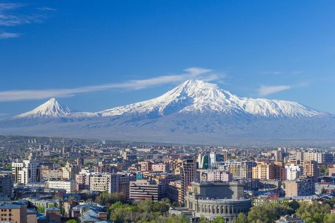
The Kingdom of Urartu was a loose confederation of fortress/cities/towns, in lands that are now occupied by modern Turkey (eastern Anatolia), Armenian Republic and Iran. Today’s neighbouring countries are Georgia, Iraq, Iran and Syria. The civilisation started approximately 13th century BCE. Some of its famous sites are Erebuni (near northern border with what is now Georgia, and now the Armenian capital city, Yerevan), Lake Van and Tushpa (ancient capital). Geographically, this area is just south of the lands between the Black Sea and the Caspian Sea (Asia Minor). The ancient city of Tushpa is today’s Van, within view of the fabled Mount Ararat. The original name of the area (Biaina) was corrupted to the more simple Van, located in the region of Tosp. It is also close to the Ararat Plain. The Armenian plateau was then known as Nairi. It was a desert region, but a farsighted King Menua achieved an engineering feat by building a stone-lined canal to bring fresh water to the city (Lake Van is salt water) 80km from the Artos Mountains (r.c. 810-785 BCE). Aqueducts were also rasied where necessary to carry the water, which is remarkable as this era pre-dates the founding of Rome. The headwaters of the Tigris and Euphrates river systems come from eastern Anatolia.
Urartu consisted of a network of interlinked and interspersed fortresses, rather than massive urban settlements. Herodotus called its people Alarodians. Hebrews called them the people of Ararat. The people of the region in ancient times called themselves Khaldians. They are believed to be the early ancestors of the Armenian population today (although a lot of people now residing in the Republic of Armenia were refugees from the Armenian genocide (perpetrated by the Ottoman Empire) in 1915.
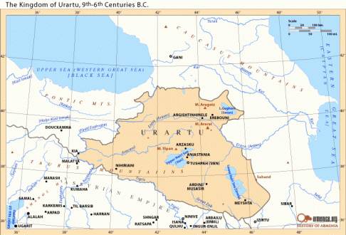
A map of the region of Urartu, bounded by the Caucasus Mountains and the Caspian Sea in the north and north-east, Pontic Mountains and the Black Sea to the north-west, and the Taurus Mountains with Semitic lands in the south (Assyrian Empire)
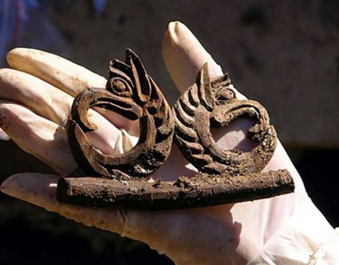
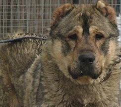
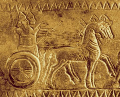
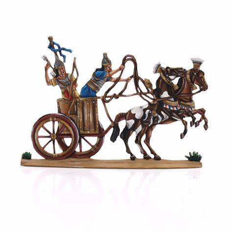
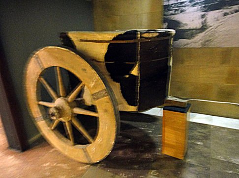
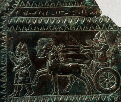
Urartu flourished in the Iron Age, and was known for advanced use of metallurgy. The region was also famous for horse-breeding. According to the Greek historian, Xenophon (430-354 BCE) at the temple of Haldi in Erebuni (the site of today’s capital city of Armenia, Yerevan) horses were sacrificed to god Khaldi and to Shivini (the Khaldian Sun God). Archaeologists uncovered grape seeds, olive oil, lentils, peas and malted barley for brewing beer. 2,800 year old seeds have been recovered through archaeological digs, and at present are being tested for viability. This agricultural plenty in a desert land was assisted by the artificial canal which created fertile fringes around the lake, near Tushpa. Further north, water was also collected in an artificial lake in the Varag Mountains for the earthern fort where King Rusas had his capital.
Although Lake Van is salt water, the land was fertile when under cultivation and irrigated.
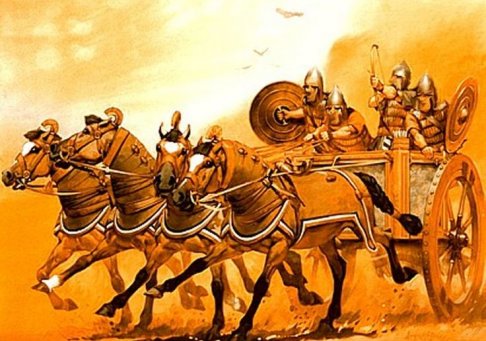
The decline of the civilisation probably started about 8th century BCE and the civilisation was fully destroyed by the end of the 6th century BCE. The area was close to major trade routes between the Mediterranean and Central Asia, and as such it was a strategic place, which underwent many wars. The main enemies of the Urartian peoples were the Assyrians (invading kings were Ashurbanipal II and Salmanasar III) in lands to the South and West of Urartu, and the Cimmerians and Scythians (from the north); and the Medians (Medes – a people of ancient Persia).
After the fall of the Urartian states in 6th Century BCE, Erebuni became a Persian satrapy of Armenia, under the Achaemenian Empire. Persian power in the area of Erebuni collapsed due to the conquests of Alexander the Great (332-323 BCE).
The root of the spoken and written languages was Hurrian (Vannic cuneiform script was found in many inscriptions at the fortress sites, and was either Assyrian cuneiform, or Khaldian script which was not Indo-European. The origins are thought to be Transcaucasian).
Hurrian is an extinct Hurro-Urartian language spoken by the Hurrians (Khurrites), a people who entered northern Mesopotamia around 2300 BC and had mostly vanished by 1000 BC. Hurrian was the language of the Mitanni kingdom in northern Mesopotamia and was likely spoken at least initially in Hurrian settlements in modern-day Syria. It is generally believed that the speakers of this language originally came from the Armenian Highlands and spread over southeast Anatolia and northern Mesopotamia at the beginning of the 2nd millennium BC.
https://en.wikipedia.org/wiki/Hurrian_language
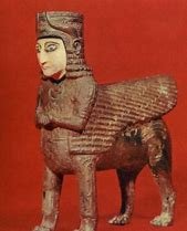
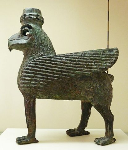
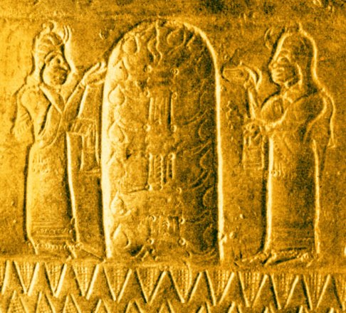
The main gods of the ancient Urartians were Khaldi, Teisheba, and Shivini (Sun God).
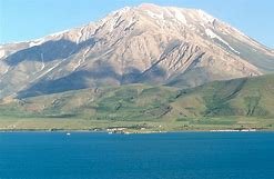
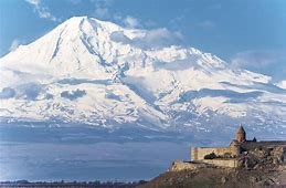
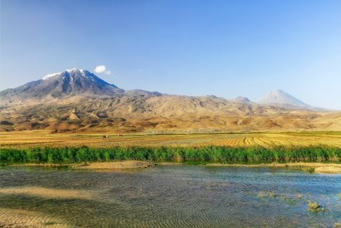
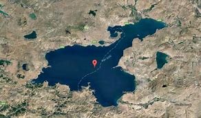
Lake Van and Mount Ararat
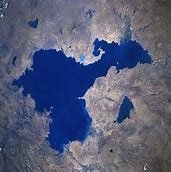
Satellite view of Lake Van The Lake in winter.
Lake Van
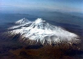
Mount Ararat is thought to be the resting place of Noah’s Ark, and is an important mountain in biblical history.
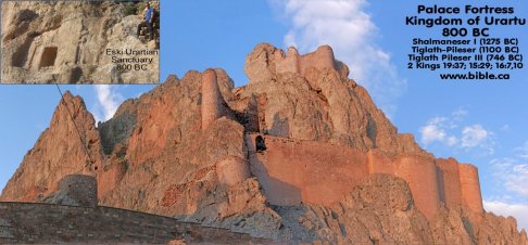
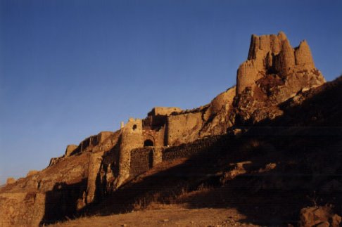
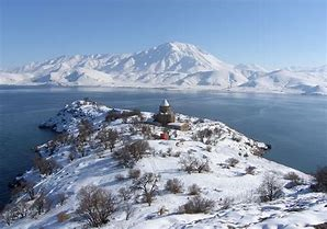
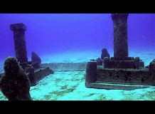
The hilltop fortress (citadel) of Van
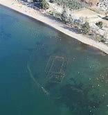
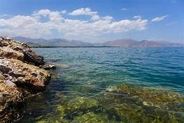
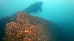
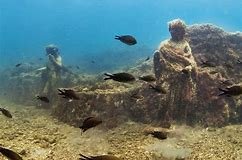
Shallow submerged ruins of a church, close to the shore in Lake Van
The Lake Van fortification is approximately 1 sq km. The building blocks for the walls were as long as 6m and as thick as 75cm. The fortress was built on a limestone promontory on the eastern shores of Lake Van. The height of the rock which gave the fortress its advantage was 115m (375 feet) from lake level. The associated township, Tushpa, was founded by King Sardur (r.c. 835 - 825 BCE). Tushpa was named after Tushpuea, the consort of Shivini (Urartian Sun God). The town had a population of 50,000 at its peak.
The famous king, Sardur III inscribed his victories on a monument erected at the site of the Treasury Gate, in the Fortress of Van. Argistis 1 inscribed his victories on the walls of chambers hewn directly in the Rock of Van.
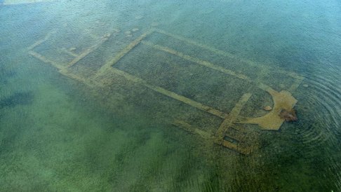
A new archaeological find:
A recent find (since 2015) has been a submerged 3,000 year old castle in Lake Van.
Foundation walls of castle Satellite view showing location of archaeological find
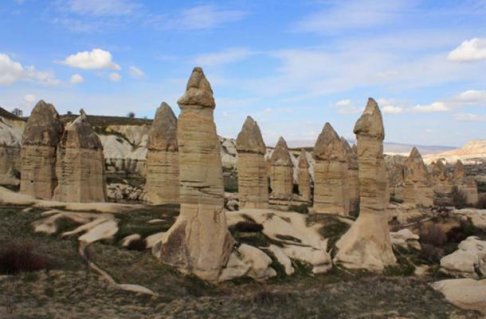
Stalagmites were found near the submerged castle (natural limestone formations which normally grow in underground cave systems). These are similar to the “fairy chimneys” also found in eastern Turkey.
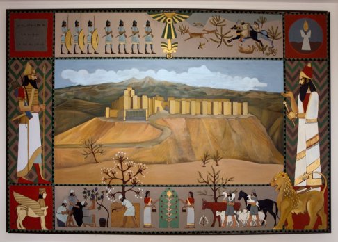
The Fortess of Arin Berd (Fortress of Blood) – also known as Erebuni
In 782 BCE, King Arguishti 1 (r.c. 786-756 BCE) built a fortress of stone on a high hill over the river Aras (65m elevation above the banks of the river). His inscription can be found on a cuneiform slab of basalt.
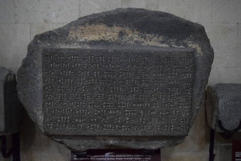
King Arguishti 1’s Vannic cuneiform inscription
In today’s map, Erebuni is found as part of Nor-Aresh District and Vardahsen District. This fortress was rediscovered in 1950 and excavated by Armenians and Soviets since then. It consisted of a citadel on top of the hill, triangular in shape (due to the geographic location); and a town or city at its base. Walls extended 12m high on the steep-sided slope, and reinforced with buttresses. This proved to be an impressive deterrent to siege and attack.
The area of Erebuni is approximately 40 hectares (99 acres), and has imposing views of Mount Ararat and the Ararat Plain. The area of the citadel included a Temple of Haldi, and there was possibly a ziggurat there too. Worship to Khaldi including sacrifice took place there. The King’s palace in the northwestern part of the hilltop was covered with wall murals on its inner walls. These depicted farming or hunting scenes, or had geometrical or vegetative designs.
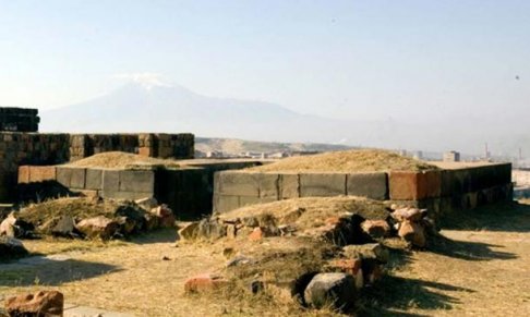
Ruins of Temple of Haldi, at Erebuni
The Kingdom of Urartu was a loose confederation of fortress/cities/towns, in lands that are now occupied by modern Turkey (eastern Anatolia), Armenian Republic and Iran. Today’s neighbouring countries are Georgia, Iraq, Iran and Syria. The civilisation started approximately 13th century BCE. Some of its famous sites are Erebuni (near northern border with what is now Georgia, and now the Armenian capital city, Yerevan), Lake Van and Tushpa (ancient capital). Geographically, this area is just south of the lands between the Black Sea and the Caspian Sea (Asia Minor). The ancient city of Tushpa is today’s Van, within view of the fabled Mount Ararat. The original name of the area (Biaina) was corrupted to the more simple Van, located in the region of Tosp. It is also close to the Ararat Plain. The Armenian plateau was then known as Nairi. It was a desert region, but a farsighted King Menua achieved an engineering feat by building a stone-lined canal to bring fresh water to the city (Lake Van is salt water) 80km from the Artos Mountains (r.c. 810-785 BCE). Aqueducts were also rasied where necessary to carry the water, which is remarkable as this era pre-dates the founding of Rome. The headwaters of the Tigris and Euphrates river systems come from eastern Anatolia.
Urartu consisted of a network of interlinked and interspersed fortresses, rather than massive urban settlements. Herodotus called its people Alarodians. Hebrews called them the people of Ararat. The people of the region in ancient times called themselves Khaldians. They are believed to be the early ancestors of the Armenian population today (although a lot of people now residing in the Republic of Armenia were refugees from the Armenian genocide (perpetrated by the Ottoman Empire) in 1915.
A map of the region of Urartu, bounded by the Caucasus Mountains and the Caspian Sea in the north and north-east, Pontic Mountains and the Black Sea to the north-west, and the Taurus Mountains with Semitic lands in the south (Assyrian Empire)
Urartu flourished in the Iron Age, and was known for advanced use of metallurgy. The region was also famous for horse-breeding. According to the Greek historian, Xenophon (430-354 BCE) at the temple of Haldi in Erebuni (the site of today’s capital city of Armenia, Yerevan) horses were sacrificed to god Khaldi and to Shivini (the Khaldian Sun God). Archaeologists uncovered grape seeds, olive oil, lentils, peas and malted barley for brewing beer. 2,800 year old seeds have been recovered through archaeological digs, and at present are being tested for viability. This agricultural plenty in a desert land was assisted by the artificial canal which created fertile fringes around the lake, near Tushpa. Further north, water was also collected in an artificial lake in the Varag Mountains for the earthern fort where King Rusas had his capital.
Although Lake Van is salt water, the land was fertile when under cultivation and irrigated.
The decline of the civilisation probably started about 8th century BCE and the civilisation was fully destroyed by the end of the 6th century BCE. The area was close to major trade routes between the Mediterranean and Central Asia, and as such it was a strategic place, which underwent many wars. The main enemies of the Urartian peoples were the Assyrians (invading kings were Ashurbanipal II and Salmanasar III) in lands to the South and West of Urartu, and the Cimmerians and Scythians (from the north); and the Medians (Medes – a people of ancient Persia).
After the fall of the Urartian states in 6th Century BCE, Erebuni became a Persian satrapy of Armenia, under the Achaemenian Empire. Persian power in the area of Erebuni collapsed due to the conquests of Alexander the Great (332-323 BCE).
The root of the spoken and written languages was Hurrian (Vannic cuneiform script was found in many inscriptions at the fortress sites, and was either Assyrian cuneiform, or Khaldian script which was not Indo-European. The origins are thought to be Transcaucasian).
Hurrian is an extinct Hurro-Urartian language spoken by the Hurrians (Khurrites), a people who entered northern Mesopotamia around 2300 BC and had mostly vanished by 1000 BC. Hurrian was the language of the Mitanni kingdom in northern Mesopotamia and was likely spoken at least initially in Hurrian settlements in modern-day Syria. It is generally believed that the speakers of this language originally came from the Armenian Highlands and spread over southeast Anatolia and northern Mesopotamia at the beginning of the 2nd millennium BC.
https://en.wikipedia.org/wiki/Hurrian_language
The main gods of the ancient Urartians were Khaldi, Teisheba, and Shivini (Sun God).
Lake Van and Mount Ararat
Satellite view of Lake Van The Lake in winter.
Lake Van
Mount Ararat is thought to be the resting place of Noah’s Ark, and is an important mountain in biblical history.
The hilltop fortress (citadel) of Van
Shallow submerged ruins of a church, close to the shore in Lake Van
The Lake Van fortification is approximately 1 sq km. The building blocks for the walls were as long as 6m and as thick as 75cm. The fortress was built on a limestone promontory on the eastern shores of Lake Van. The height of the rock which gave the fortress its advantage was 115m (375 feet) from lake level. The associated township, Tushpa, was founded by King Sardur (r.c. 835 - 825 BCE). Tushpa was named after Tushpuea, the consort of Shivini (Urartian Sun God). The town had a population of 50,000 at its peak.
The famous king, Sardur III inscribed his victories on a monument erected at the site of the Treasury Gate, in the Fortress of Van. Argistis 1 inscribed his victories on the walls of chambers hewn directly in the Rock of Van.
A new archaeological find:
A recent find (since 2015) has been a submerged 3,000 year old castle in Lake Van.
Foundation walls of castle Satellite view showing location of archaeological find
Stalagmites were found near the submerged castle (natural limestone formations which normally grow in underground cave systems). These are similar to the “fairy chimneys” also found in eastern Turkey.
The Fortess of Arin Berd (Fortress of Blood) – also known as Erebuni
Yerevan (/jɛrəˈvɑːn/ YERR-ə-VAHN; Armenian: Երևան[a] [jɛɾɛˈvɑn] (listen), sometimes spelled Erevan)https://en.wikipedia.org/wiki/Yerevan#cite_note-17 is the capital and largest city of Armenia as well as one of the world's oldest continuously inhabited cities.[16] Situated along the Hrazdan River, Yerevan is the administrative, cultural, and industrial center of the country. It has been the capital since 1918, the fourteenth in the history of Armenia and the seventh located in or around the Ararat plain. …
The history of Yerevan dates back to the 8th century BC, with the founding of the fortress of Erebuni in 782 BC by king Argishti I at the western extreme of the Ararat plain.[18] Erebuni was "designed as a great administrative and religious centre, a fully royal capital."[19] By the late ancient Armenian Kingdom, new capital cities were established and Yerevan declined in importance… The city expanded rapidly during the 20th century as Armenia became part of the Soviet Union. In a few decades, Yerevan was transformed from a provincial town within the Russian Empire to Armenia's principal cultural, artistic, and industrial center, as well as becoming the seat of national government.
Of the notable landmarks of Yerevan, Erebuni Fortress is considered to be the birthplace of the city…
In 782 BCE, King Arguishti 1 (r.c. 786-756 BCE) built a fortress of stone on a high hill over the river Aras (65m elevation above the banks of the river). His inscription can be found on a cuneiform slab of basalt.
King Arguishti 1’s Vannic cuneiform inscription
In today’s map, Erebuni is found as part of Nor-Aresh District and Vardahsen District. This fortress was rediscovered in 1950 and excavated by Armenians and Soviets since then. It consisted of a citadel on top of the hill, triangular in shape (due to the geographic location); and a town or city at its base. Walls extended 12m high on the steep-sided slope, and reinforced with buttresses. This proved to be an impressive deterrent to siege and attack.
The area of Erebuni is approximately 40 hectares (99 acres), and has imposing views of Mount Ararat and the Ararat Plain. The area of the citadel included a Temple of Haldi, and there was possibly a ziggurat there too. Worship to Khaldi including sacrifice took place there. The King’s palace in the northwestern part of the hilltop was covered with wall murals on its inner walls. These depicted farming or hunting scenes, or had geometrical or vegetative designs.
Ruins of Temple of Haldi, at Erebuni
Last edited:
")