The Enormity (1 Viewer)

  • Welcome to the Roundtable! If you have an account already, please sign in, otherwise feel free to register. Note that you will be unable to post or access some boards and information unless you sign in.

Snowmelt

Snowmelt
Staff member
RT Supporter
Board Moderator
Aug 15, 2016
5,325
13,885
Perth, Western Australia
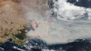
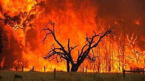
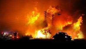
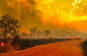
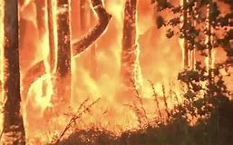
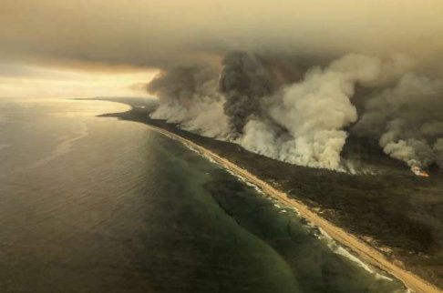
Everyone around the world is aware that there is a bushfire crisis in Australia at the moment. I thought I would share what that looks like.
Some of the photos available are too distressing to post. This situation is so widespread (across thousands of miles), and the views from the satellite let you see what ends up in the atmosphere. In one place, there was a fire tornado that was so strong, it flipped a 10-ton firetruck (unfortunately, someone inside the truck was deceased). Now the military and the navy have stepped in, removing thousands of people from shorelines and beaches, who had nowhere else to go. There have been more than 100 bushfires in Victoria/South Australia/New South Wales/Western Australia and Queensland since September 2019 and more than 17 people have died.

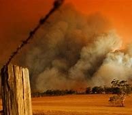
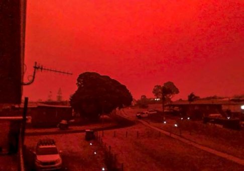
Sometimes, the depth of cloud literally turns the daylight into midnight - going pitch black, with no warning. This is how much smoke and burning material has risen into the stratosphere, blocking the light of the sun. Even passenger planes have flown from daylight into pitch black, having been given no warning due to this not showing up on radar (hello, revise the air routes!)
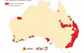
locations of the fires_mainly coastal.jpg
The Australasian Fire and Emergency Service Authorities Council (AFAC)

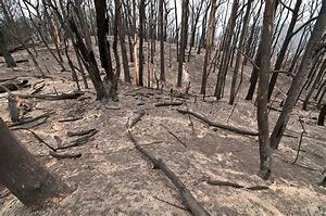
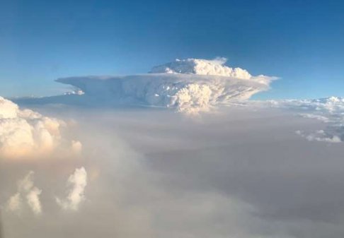
I have learned a new word - pyrocumulus cloud. This describes all the carbon and material that is burnt and transformed into smoke, including trees, topsoil, vegetation etc. Virtually nothing is left in the aftermath. I know many other parts of the world have suffered in 2019 and other years, as we do on an annual basis. But the scope of this quells our ideas of our place on the globe, to know that life here is transitory and granted by grace.
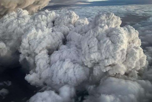
Pyrocumulus clouds from eastern Australian bushfires_Jan 2020.jpg
Pyrocumulus cloud

Satellite photo of bushfire created clouds over southeastern Australia.jpg
Satellite photo of the affected area (south eastern Australia) with smoke wafting over the Tasman Sea towards New Zealand, turning the skies of the North Island into a pale orange.
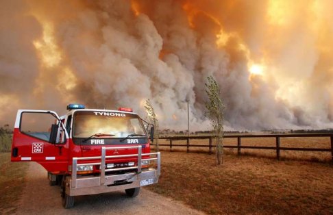
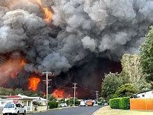
Bushfire_carbon burning becoming smoke clouds.jpg

ominous fire approaching.jpg

Fire_1.pngFire_2.jpgfire_3.jpg

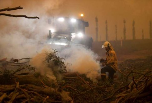
fire_4.jpgfire_5.jpgfiries trying to stop the fires.jpg

literally nothing left on forest floor.jpg
Literally nothing is left on the forest floor
 
Last edited:
OP
Snowmelt

Snowmelt

Snowmelt
Staff member
RT Supporter
Board Moderator
Aug 15, 2016
5,325
13,885
Perth, Western Australia
I'm quite proud of my twin brother - managed to speak to him. He and his wife are coordinating response teams to feed people in an evacuation centre in their town, and providing 5 meals a day to 100 plus firefighters at a remote location (Snowy Mountains region). This is 24/7 and they are catching about 3-4 hours sleep a day, and have been going since before Christmas.
 

Tristan

Involved Wayfarer
RT Supporter
Apr 28, 2017
152
495
I'm quite proud of my twin brother - managed to speak to him. He and his wife are coordinating response teams to feed people in an evacuation centre in their town, and providing 5 meals a day to 100 plus firefighters at a remote location (Snowy Mountains region). This is 24/7 and they are catching about 3-4 hours sleep a day, and have been going since before Christmas.
That's so great when people come together to help out those less fortunate. My mother has been front line as first responder in the state emergency service. Every day she tells us stories of ordinary people paying for response vehicle fuel ups and purchasing lunches and drinks for anyone in service uniforms.

These Pyrocumulous cloud can actually produce their own storms!
 

therium

Involved Wayfarer
RT Supporter
Nov 1, 2018
1,423
2,740
Michigan
Isn't this an area in Australia that is prone to fires for some reason?

Let me try to explain what I know about California fires.

California fires happen in a certain area due to geographical and environmental issues. The mountains in Cali run north-south, so are open to the most intense sunlight during midday, which leads to a drying action. Droughts in Cali are also more common than in other areas but I haven't found the reason for that. This is also a big area with lots of trees. And a breeze from the sea circulates from west to east further drying out other areas. Thus when a fire starts, the conditions are already set up for a big fire that's hard to fight, with lots of very dry fuel. Plus if the fire starts near the bottom of the mountains, the sea breeze fans the flames nicely, and, since heat rises, the fire travels easily eastward and up the very tree-studded mountains. Also it is the policy of California to make sure no preemptive burning happens by humans (to remove the highly flammable dead underbrush), which makes it much easier to start, and fuel, hotter fires via a larger volume of very dry dead wood. Also some areas in Cali have lots of pine trees, the pitch of which make them even more flammable.

There is at least one species of pine in California that has adapted to frequent fires. The seeds from the pine cone won't open unless a fire burns it. Thus it seems, frequent fires have been a thing in Cali for a very long time, even before European people settled there.

So when people say "California brought this on itself" it's partially true, but it's not the whole truth.
 
Last edited:
  • Informative
Reactions: Alain and Lila

Pucksterguy

Elder Entity
Jul 28, 2016
1,998
6,523
Also it is the policy of California to make sure no preemptive burning happens by humans (to remove the highly flammable dead underbrush), which makes it much easier to start, and fuel, hotter fires via a larger volume of very dry dead wood. Also some areas in Cali have lots of pine trees, the pitch of which make them even more flammable.
We also have the same issues here in Canada. Fires have always been natures clean up system. dead undergrowth gets burned off at a relatively lower temp that doesn't affect healthy trees much. This in turn fertilizes the soil and promotes fresh tree growth and habitat for various animals. Here too out of malice(at worst) or ignorance(at best) all fires are extinguished immediately. Causing the undergrowth to linger and get worse. To be fair the authorities have or ar changing this policy to allow for the undergrowth to be burned off and prevent the larger catastrofic fires from consuming the few old growth forests we have left. Canada is still (thank God) mostly covered in forest and wood harvesting is moving away from the clear cutting practices of yesteryear. Man is making progress but not fast enough.
 
OP
Snowmelt

Snowmelt

Snowmelt
Staff member
RT Supporter
Board Moderator
Aug 15, 2016
5,325
13,885
Perth, Western Australia
Isn't this an area in Australia that is prone to fires for some reason?

Let me try to explain what I know about California fires.

Also it is the policy of California to make sure no pre-emptive burning happens by humans (to remove the highly flammable dead underbrush)
Good analysis, I would say. Our whole east coast of Australia definitely suffers from the El Nino/La Nina effect, leading to drought and then flood conditions. A catastrophic pendulum of sorts. I post a short vid below to explain about that. Both California and our east coast are Pacific Rim, so what goes on in the equatorial Pacific has a huge impact.

But your mention of it being the policy of state of California not to do brush-burning does shock me. Over here in Western Australia, we have annual winter burns, which creates smoke haze over our capital city (which gets the whingers and moaners going, and can be quite uncomfortable, depending on conditions can last 5-6 days). We still have had catastrophic fires, even with these precautions. 5 years ago a small town near Perth (Yarloop) was completely burnt to the ground. That is now just a foretaste of what is going on over East. My family over East have told me the brush-burning has not been going on over there for decades. What could that be about? Similar to the pine cone, eucalypt oil from all our native species growing thickly in natural bush settings is combustive.

People want to live in lovely natural bush settings (along with the leeches, eew), but balance in replanting and burning off must be done in our climate and conditions.

 
  • Helpful Post
Reactions: Alain and Lila
OP
Snowmelt

Snowmelt

Snowmelt
Staff member
RT Supporter
Board Moderator
Aug 15, 2016
5,325
13,885
Perth, Western Australia
Rain gods must have listened, as there has been a reprieve (cooling rain in some parts - dampening down embers, at least). Don't forget we are 3 months into this experience with probably another month before things can be called "over".

Some more dramatic images to share:

sky glows red at Mallacoota Jan 4.jpg
Sky glows red over Mallacoota (Victoria) Jan 4

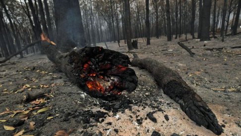
log burns in aftermath.jpg
log burns in aftermath

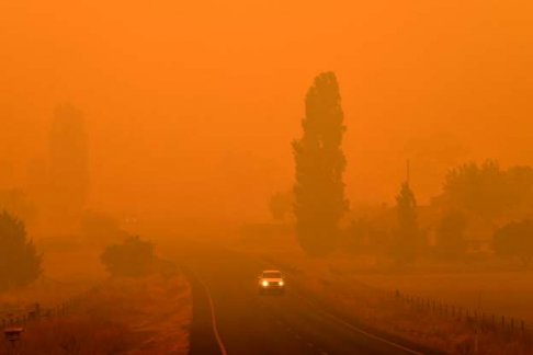
bemboka new south wales.jpg
The air quality everyone in south-east Australia is breathing

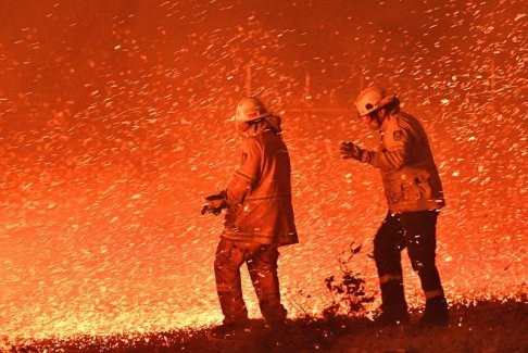
firies at Nowra in a strong wind.jpg
Firies in a strong wind at the firefront at Nowra, New South Wales

pyrocumulus cloud formation.jpg
pyrocumulus clouds

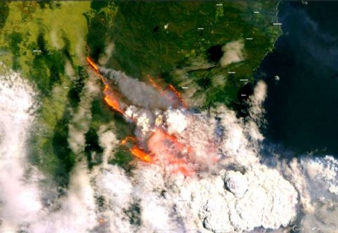
satellite of firefront.jpg
Satellite image of firefront near Batemans Bay, New South Wales

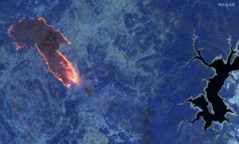
Near Lake Eucumbene in Snowy Mountains.jpg
Satellite image of firefront near Lake Eucumbene, Kosciusko, Snowy Mountains, near the town where my brother is assisting

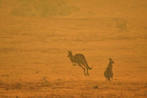
kangaroos dealing with the destruction of their habitat.jpg
Animals face destruction of their habitat

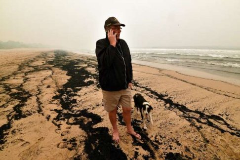
soot on beach.jpg
It is wrong to think you can wait it out on the beach. Those are soot lines, washed up by the tide.

East Gippsland Victoria.jpg
And that's how close it got to beaches in East Gippsland, Victoria

Firies.jpg
Thank god for the firies

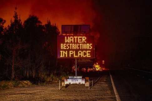
water restrictions in place.jpg
Kind of obvious, but humorous in a way...
 
  • A hug for you
Reactions: Alain and Bert

Lila

Collected Consciousness
Staff member
RT Supporter
Global Moderator
Board Moderator
Jul 28, 2016
4,806
10,199
Wow, Hailstones Melt. I'd heard about this during the holidays.
Your pictures add a whole new element to the stories I've heard and captures a bit of the scope.
Really appreciate that.
 
  • I agree
Reactions: Alain

Bert

Involved Wayfarer
RT Supporter
Jan 10, 2019
352
779
Belgium
Also it is the policy of California to make sure no preemptive burning happens by humans (to remove the highly flammable dead underbrush), which makes it much easier to start, and fuel, hotter fires via a larger volume of very dry dead wood. Also some areas in Cali have lots of pine trees, the pitch of which make them even more flammable.

There is at least one species of pine in California that has adapted to frequent fires. The seeds from the pine cone won't open unless a fire burns it. Thus it seems, frequent fires have been a thing in Cali for a very long time.
two year ago we were in Sequoia National Park and there they explicitly stated that they indeed did it wrong for the last 60-100 years and that they are now doing preemptive burning, when the conditions are right for a low temperature fire, to remove fuel material that piled up during all these years.
of course this is in a national park. don't know if this is already applied outside the park but the knowledge and experience is there.

The pine species you are talking about is the sequoia. it needs regular forest fires to grow (to germinate and to remove other pines that grow faster but are not tolerant to the fires as the sequoia is).
 
OP
Snowmelt

Snowmelt

Snowmelt
Staff member
RT Supporter
Board Moderator
Aug 15, 2016
5,325
13,885
Perth, Western Australia
Posting on January 11, good news that fire weather has been kinder to our locations under bushfire emergency, meaning some cooling rains arrived in the nick of time, to some places, and cooler temperatures allowed very short reprieves, such as more back-burning etc, and a little bit of extra kip (sleep, to translate for you non-Aussies!)

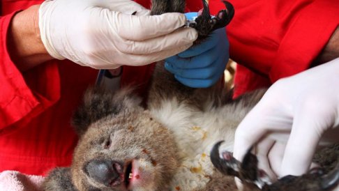
Our veterinarians have been busy helping our injured wildlife:

injured koala.jpg
 

Alain

Roaming Contributor
RT Supporter
Aug 29, 2017
2,238
4,508
Fire tornado i saw one in a movie of a forest fire by areson, impressif power the nature is capable to show on all borders,

Tragic such things happen but like the phoenix out of the ashes comes new
 

Alain

Roaming Contributor
RT Supporter
Aug 29, 2017
2,238
4,508
I'm quite proud of my twin brother - managed to speak to him. He and his wife are coordinating response teams to feed people in an evacuation centre in their town, and providing 5 meals a day to 100 plus firefighters at a remote location (Snowy Mountains region). This is 24/7 and they are catching about 3-4 hours sleep a day, and have been going since before Christmas.
I surely need more sleep than that, my respect to those who can be fully operational in these conditions
 
  • I agree
  • Love this post!
Reactions: Lila and Snowmelt
OP
Snowmelt

Snowmelt

Snowmelt
Staff member
RT Supporter
Board Moderator
Aug 15, 2016
5,325
13,885
Perth, Western Australia
Fire tornado i saw one in a movie of a forest fire by areson, impressif power the nature is capable to show on all borders,

Tragic such things happen but like the phoenix out of the ashes comes new
Alain, as Janne mentioned on another thread, the cycle of bushfire and renewal is ages old in Australia - the Aboriginals understood its ways far better than the white man, who only showed up here 232 years ago.
 

therium

Involved Wayfarer
RT Supporter
Nov 1, 2018
1,423
2,740
Michigan
I found some maps for Australia fires. https://www.google.com/search?client=firefox-b-1-d&q=map+of+australia+fires

When you open a map make sure it's a current map, not from years ago.

I hope everyone is safe.

Interactive map updates every 2-4 hours. https://myfirewatch.landgate.wa.gov.au/

These various maps let you track fire locations, air quality, smoke, etc. https://www.fastcompany.com/90448701/these-australia-fire-maps-let-you-track-air-quality-and-smoke-as-bushfires-continue

Google's Crisis map for Australia. https://google.org/crisismap/australia

NOAA real-time satellite imagry interactive map. https://www.nesdis.noaa.gov/content/imagery-and-data

VOX has some still pictures of the fires as seen from space. https://www.vox.com/2020/1/3/21048700/australia-fires-2019-map-satellite-smoke-pollution

Still pics of the files from NASA. https://www.nasa.gov/image-feature/goddard/2020/rains-bring-very-temporary-relief-to-australias-fires
 
Last edited:
OP
Snowmelt

Snowmelt

Snowmelt
Staff member
RT Supporter
Board Moderator
Aug 15, 2016
5,325
13,885
Perth, Western Australia
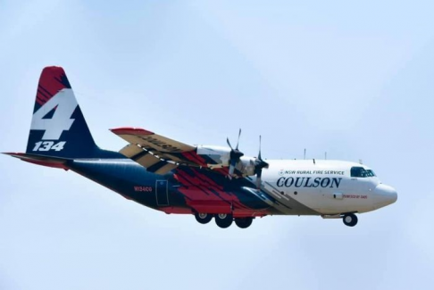
We are in sincere shock that three American firefighters who travelled to our east coast of Australia to help with the fire effort have perished when their RFS Coulson aircraft crashed near the fire scene and was totally obliterated. The plane was carrying a full load of fire retardant to drop on the fire-affected area. It crashed into a ridge at Peak View, about 6kms from a fire base camp where my brother has been helping to feed the crews.

The aircraft was a NSW Rural Fire Service plane, brought into Australia about a year ago. It was a Lockheed C-130 (Large Air Tanker), and manned by Coulson aircrew. It had flown from Richmond Airfield (near Sydney) to south of Canberra - a journey of about one and a half hours - before it plummeted into the mountains.

C130 Large Air Tanker Coulson aircraft.png

I send my love to the families of those three brave men who lost their lives while in service to the highest good.
 
Last edited:

Linda

Sweetheart of the Rodeo
Staff member
Global Moderator
Administrator
Board Moderator
Jul 20, 2016
6,572
20,210
Just learned that Au and the US have had a joint alliance for fire emergencies for many years and fire fighters from each country have come to the aid of the other 12 times.
 
  • Cool Post
  • Like
Reactions: Lila and Alain

Users Who Are Viewing This Thread (Users: 0, Guests: 1)